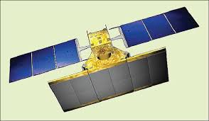
Radar Imaging Satellite 1A, or RISAT-1A, is a planned remote sensingsatellite that is similar in configuration to RISAT-1. The satellite is being developed by Indian Space Research Organisation (ISRO). RISAT-1A will be 6th in series of RISAT satellites. It will be a land based mission with primary application in terrain mapping and analysis of land, ocean and water surface for soil moisture.
Payloads :
The satellite will carry Synthetic Aperture Radar which will operate at 5.35 GHz in C band. Synthetic Aperture Radar can be used for earth observation irrespective of the light and weather conditions of the area being imaged.[3]
Payload metrics are defined by the following parameters and areas of study
| Category | Parameters |
|---|---|
| Land | Albedo and reflectance |
| Land | Soil moisture |
| Land | Vegetation |
| Land | Multi-purpose imagery |
| Ocean | Ocean topography/currents |
| Snow & Ice | Ice sheet topography |
| Snow & Ice | Snow cover, edge and depth |
| Snow & Ice | Sea ice cover, edge and thickness |
Spacecraft :
RISAT-1A will be launched on the Polar Satellite Launch Vehicle (PSLV) and will have a liftoff mass of 1,858 kilograms (4,096 lb).
Launch :
RISAT-1A is planned to be launched in March 2020.
If we sum up everything :
| Mission type | Radar imaging satellite |
|---|---|
| Operator | ISRO |
| Mission duration | 5 years (planned) |
| Spacecraft properties | |
| Manufacturer | Space Applications Centre |
| Launch mass | 1,858 kilograms (4,096 lb) |
| Power | 2200 w |
| Start of mission | |
| Launch date | March 2020 (planned) |
| Launch site | Satish Dhawan Space Centre |
| Orbital parameters | |
| Reference system | Geocentric |
| Regime | Sun-synchronous |
| Inclination | 97.844 deg |
| Period | 96.5 minutes |
references : wikipedia
